IndigoGenius (talk | contribs) |
IndigoGenius (talk | contribs) No edit summary |
||
| (35 intermediate revisions by the same user not shown) | |||
| Line 1: | Line 1: | ||
| − | [[Image: |
+ | [[Image:Totummoa-map.png|thumb|650px|Map showing the location of the islands in the Pacific Ocean on the first two frames, the islands in the Caribbean Sea in the third to the right, and the City of Cyberterra in the rightmost frame (all the UMMOA islands are highlighted in red)]]The ''United States Minor Outlying Islands'' (''USMOI''), a statistical designation defined by the International Organization for Standardization's ISO 3166-1 code, consists of eleven [[United States]] insular areas. |
| − | Palmyra Atoll is the only incorporated territory. As of 2008, none of the islands |
+ | Palmyra Atoll is the only incorporated territory. As of 2008, none of the islands have any permanent residents. The only human population consists of temporarily stationed scientific and military personnel. The 2000 census counted 315 people on Johnston Atoll, and 1 person on Wake Island.<sup>1</sup> There has been no indigenous population, except in the 1940 census. The Baker, Howland and Jarvis Colonization Scheme attempted to settle Americans on those three islands beginning in 1935, but all three islands were evacuated in 1942 as a result of World War II. |
| − | The term "United States Minor Outlying Islands" was introduced in 1986. From 1974 until 1986, five of the islands (Baker Island, Howland Island, Jarvis Island, Palmyra Atoll and Kingman Reef) were grouped under the term US Miscellaneous Pacific Islands, with ISO 3166 code PU (the code of Midway Atoll was MI, and the code of Johnston Atoll JT). |
+ | The term "United States Minor Outlying Islands" was introduced in 1986. From 1974 until 1986, five of the islands (Baker Island, Howland Island, Jarvis Island, Palmyra Atoll and Kingman Reef) were grouped under the term ''US Miscellaneous Pacific Islands'', with ISO 3166 code PU (the code of Midway Atoll was MI, and the code of Johnston Atoll JT). |
| − | The islands are grouped together entirely as a statistical convenience. They are not administered collectively, nor do they share a single cultural or political history beyond being currently uninhabited islands under the sovereignty of the United States. |
+ | The islands are grouped together entirely as a statistical convenience (they are not a '''real territory''' in [[Montevideo Convention]] terms, even though the entity is associated with real natural islands). They are not administered collectively (they are not a '''real country''' or state), nor do they share a single cultural or political history beyond being currently uninhabited islands under the sovereignty of the United States (they are not a '''real nation'''). |
| − | They are collectively represented today by the ISO 3166-1 alpha-2 code UM. The individual islands have ISO 3166-2 numerical codes, |
+ | They are collectively represented today by the ISO 3166-1 alpha-2 code UM. The individual islands have ISO 3166-2 numerical codes, but the situation is highly irregular, since only 9 out of the 11 insular areas have ISO 3166-2 numerical codes.<sup>2</sup> The Internet country code top-level domain (ccTLD) ".um" has historically been assigned to the islands; however, the .um ccTLD was retired in January 2007.<sup>3</sup> The .um ccTLD, however, was not abandoned immediately. |
| − | The Internet country code top-level domain (ccTLD) ".um" has historically been assigned to the islands; however, the .um ccTLD was retired in January 2007.<sup>2</sup> The .um ccTLD, however, was not abandoned immediately. |
||
| + | ==The Invasion== |
||
| − | On 6 May 2008 with [[Cesidian Root]] officers, [[Cesidio Tallini]] claims to have invaded the .UM ccTLD in the Cesidian Root, i.e. United States namespace, and to have legally annexed the ''United States Minor Outlying Islands'' (''USMOI''). He renamed the islands the [[UMMOA|'''United Micronations Multi-Oceanic Archipelago''']] '''(UMMOA)'''.<sup>3</sup> [[Cesidio Tallini|Tallini]] is now the Governor of the [[UMMOA]]. |
||
| + | On 6 May 2008 with [[Cesidian Root]] officers, [[Cesidio Tallini]] claims to have invaded the .um ccTLD in the Cesidian Root, i.e. United States namespace, and to have legally annexed the ''United States Minor Outlying Islands'' (''USMOI''). He renamed the islands the '''[[United Micronations Multi-Oceanic Archipelago]] (UMMOA)'''.<sup>4</sup> [[Cesidio Tallini|Tallini]] is now the Governor of the [[UMMOA]]. |
||
| − | [[Cesidio Tallini|Tallini]] has succeeded in having this claim recognised to a degree. On 22 July 2008 the Supreme Council of the Presidency of the [http://www.parlamentomondialedeglistati.org/start_english.htm International States Parliament for Safety and Peace] (ISPSP), New Society of the Nations, with the approval of His Excellency The Lord President, Monsignor Senator Viktor Busà, granted Accreditation and Official Status of Incorporation to the [[UMMOA|United Micronations Multi-Oceanic Archipelago]] (UMMOA), also known as the ''Arcipelago Multioceanico delle Micronazioni Unite'' (''AMOMU''), with seat in the Caribbean Sea. The [[UMMOA]] is now recognised under [[international law]] and the Vienna Convention of 18 April 1961 (1963).<sup>4</sup> |
||
| + | |||
| + | [[Cesidio Tallini|Tallini]] has succeeded in having this claim recognised juridically to a degree. On 22 July 2008 the Supreme Council of the Presidency of the [http://www.parlamentomondialedeglistati.org/start_english.htm International States Parliament for Safety and Peace] (ISPSP), New Society of the Nations, with the approval of His Excellency The Lord President, Monsignor Senator Viktor Busà, granted Accreditation and Official Status of Incorporation to the [[United Micronations Multi-Oceanic Archipelago]] (UMMOA), also known as the ''Arcipelago Multioceanico delle Micronazioni Unite'' (''AMOMU''), with seat in the Caribbean Sea. The [[UMMOA]] is now recognised under [[international law]] and the Vienna Convention of 18 April 1961 (1963).<sup>5</sup> |
||
| + | |||
| + | ==Post-Invasion Period== |
||
| + | |||
| + | With the growth of the [[United Micronations Multi-Oceanic Archipelago]] (UMMOA) as a nation, what was formerly just a US territory, and an irregular territory at best, has begun to grow and diversify. The [[UMMOA]] today is more than just the physical ''[[USMOI]]'', since the [[Cyberterra|City of Cyberterra]] became the virtual capital of the UMMOA, and thus the virtual city has merged with the eleven original insular areas, and has become a very real twelfth insular area. When added to the UMMOA Community of Nations, the twelfth national component, Cyberterra can be considered the UMMOA's thirteenth national component. |
||
| + | |||
| + | On 6 August 2010, the fourteenth national component came into being, the Fifth World Community, an inhabited locality, but also the world's first ''diaxenospitia''. |
||
| + | |||
| + | On 7 January 2010, the fifteenth national component came into being when the Governor of the UMMOA claimed a piece of the Great Pacific Garbage Patch (GPGP), a ''diaxenospitia'' of jetsam, rather than of buildings. |
||
| + | |||
| + | On 23 June 2011, the sixteenth national component came into being when the Governor of the UMMOA claimed a piece of every oceanic garbage patch, and launched the Multi-Oceanic Garbage Patch Treaty (MOGPT) website. |
||
| + | |||
| + | On 26 June 2011, the seventeenth national component came into being when the Governor of the UMMOA claimed a piece of all of the space debris, and and launched the Space Debris Treaty (SDT) website. |
||
| + | |||
| + | On 20 August 2011, with a great suggestion of the Hon. Ilya Pakhomov, the UMMOA decided to claim an 18th, 19th, 20th, 21st, 22nd, 23th, and 24th national component. Therefore the UMMOA now claims the following disappearing islands: Ghoramara Island (India), Lohachara Island (India), Bedford Island (India), New Moore/South Talpatti (India/Bangladesh), Tebua Tarawa (Kiribati), Bikeman Island (Kiribati) and Abanuea (Kiribati). |
||
==Atolls/Islands and Codes== |
==Atolls/Islands and Codes== |
||
| Line 20: | Line 35: | ||
<td |
<td |
||
style="vertical-align: top; background-color: rgb(238, 238, 238); font-weight: bold;" |
style="vertical-align: top; background-color: rgb(238, 238, 238); font-weight: bold;" |
||
| − | width="50"><font size=" |
+ | width="50"><font size="3">UM Code</font></td> |
<td |
<td |
||
style="vertical-align: top; background-color: rgb(238, 238, 238); font-weight: bold;" |
style="vertical-align: top; background-color: rgb(238, 238, 238); font-weight: bold;" |
||
| − | width=" |
+ | width="100"><font size="3">Atoll/Island</font></td> |
| + | <td |
||
| + | style="vertical-align: top; background-color: rgb(238, 238, 238); font-weight: bold;" |
||
| + | width="100"><font size="3">Amateur Radio Call Sign</font></td> |
||
| + | <td |
||
| + | style="vertical-align: top; background-color: rgb(238, 238, 238); font-weight: bold;" |
||
| + | width="100"><font size="3">CB Radio Call Sign</font></td> |
||
| + | <td |
||
| + | style="vertical-align: top; background-color: rgb(238, 238, 238); font-weight: bold;" |
||
| + | width="100"><font size="3">Claimed By</font></td> |
||
| + | <td |
||
| + | style="vertical-align: top; background-color: rgb(238, 238, 238); font-weight: bold;" |
||
| + | width="100"><font size="3">Continent(s)</font></td> |
||
</tr> |
</tr> |
||
<tr> |
<tr> |
||
| − | <td style="vertical-align: top;"> |
+ | <td style="vertical-align: top;">um-ct</td> |
| + | <td style="vertical-align: top;">[http://geo.cyberterra.net Cyberterra]</td> |
||
| − | </td> |
||
| − | + | <td style="vertical-align: top;">IL6</td> |
|
| + | <td style="vertical-align: top;"></td> |
||
| − | </td> |
||
| + | <td style="vertical-align: top;">UMMOA</td> |
||
| + | <td style="vertical-align: top;">Europe</td> |
||
</tr> |
</tr> |
||
<tr> |
<tr> |
||
| − | <td style="vertical-align: top;"> |
+ | <td style="vertical-align: top;">um-ni</td> |
| + | <td style="vertical-align: top;">[http://ni.ummoa.com Navassa Island]</td> |
||
| − | </td> |
||
| − | + | <td style="vertical-align: top;">KP1</td> |
|
| + | <td style="vertical-align: top;">247</td> |
||
| − | </td> |
||
| + | <td style="vertical-align: top;">US, UMMOA, and Haiti</td> |
||
| + | <td style="vertical-align: top;">North America</td> |
||
</tr> |
</tr> |
||
<tr> |
<tr> |
||
| − | <td style="vertical-align: top;"> |
+ | <td style="vertical-align: top;">um-bj</td> |
| + | <td style="vertical-align: top;">[http://maps.yahoo.com/broadband/#mvt=s&lat=15.86484&lon=-78.649907&mag=11&zoom=13&trf=0 Bajo Nuevo Bank]</td> |
||
| − | </td> |
||
| − | + | <td style="vertical-align: top;">KP3</td> |
|
| + | <td style="vertical-align: top;"></td> |
||
| − | </td> |
||
| + | <td style="vertical-align: top;">US, UMMOA, Colombia, Jamaica, and Nicaragua</td> |
||
| + | <td style="vertical-align: top;">North America</td> |
||
</tr> |
</tr> |
||
<tr> |
<tr> |
||
| − | <td style="vertical-align: top;"> |
+ | <td style="vertical-align: top;">um-sb</td> |
| + | <td style="vertical-align: top;">[http://maps.yahoo.com/broadband/#mvt=s&lat=15.774892&lon=-79.71133&mag=11&zoom=14&trf=0 Serranilla Bank]</td> |
||
| − | </td> |
||
| − | + | <td style="vertical-align: top;">KP3</td> |
|
| + | <td style="vertical-align: top;"></td> |
||
| − | </td> |
||
| + | <td style="vertical-align: top;">US, UMMOA, Colombia, Jamaica, and Nicaragua</td> |
||
| + | <td style="vertical-align: top;">North America</td> |
||
</tr> |
</tr> |
||
<tr> |
<tr> |
||
| − | <td style="vertical-align: top;">jv< |
+ | <td style="vertical-align: top;">um-jv</td> |
| + | <td style="vertical-align: top;">[http://jv.ummoa.com Jarvis Island]</td> |
||
| − | </td> |
||
| − | + | <td style="vertical-align: top;">KH5</td> |
|
| + | <td style="vertical-align: top;">273</td> |
||
| − | </td> |
||
| + | <td style="vertical-align: top;">US and UMMOA</td> |
||
| + | <td style="vertical-align: top;">Oceania</td> |
||
</tr> |
</tr> |
||
<tr> |
<tr> |
||
| − | <td style="vertical-align: top;"> |
+ | <td style="vertical-align: top;">um-pa</td> |
| + | <td style="vertical-align: top;">[http://maps.yahoo.com/broadband/#mvt=s&lat=5.880467&lon=-162.077608&mag=11&zoom=14&trf=0 Palmyra Atoll]</td> |
||
| − | </td> |
||
| − | + | <td style="vertical-align: top;">KH5</td> |
|
| + | <td style="vertical-align: top;"></td> |
||
| − | </td> |
||
| + | <td style="vertical-align: top;">US and UMMOA</td> |
||
| + | <td style="vertical-align: top;">Oceania</td> |
||
</tr> |
</tr> |
||
<tr> |
<tr> |
||
| − | <td style="vertical-align: top;"> |
+ | <td style="vertical-align: top;">um-kr</td> |
| + | <td style="vertical-align: top;">[http://kr.ummoa.com Kingman Reef]</td> |
||
| − | </td> |
||
| − | + | <td style="vertical-align: top;">KH5K</td> |
|
| + | <td style="vertical-align: top;">264</td> |
||
| − | </td> |
||
| + | <td style="vertical-align: top;">US and UMMOA</td> |
||
| + | <td style="vertical-align: top;">Oceania</td> |
||
</tr> |
</tr> |
||
<tr> |
<tr> |
||
| − | <td style="vertical-align: top;"> |
+ | <td style="vertical-align: top;">um-jn</td> |
| + | <td style="vertical-align: top;">[http://jn.ummoa.com Johnston Atoll]</td> |
||
| − | </td> |
||
| − | + | <td style="vertical-align: top;">KH3</td> |
|
| + | <td style="vertical-align: top;">262</td> |
||
| − | </td> |
||
| + | <td style="vertical-align: top;">US and UMMOA</td> |
||
| + | <td style="vertical-align: top;">Oceania</td> |
||
</tr> |
</tr> |
||
<tr> |
<tr> |
||
| − | <td style="vertical-align: top;"> |
+ | <td style="vertical-align: top;">um-bk</td> |
| + | <td style="vertical-align: top;">[http://maps.yahoo.com/broadband/#mvt=s&lat=0.195292&lon=-176.47809&mag=11&zoom=16&trf=0 Baker Island]</td> |
||
| − | </td> |
||
| − | + | <td style="vertical-align: top;">KH1</td> |
|
| + | <td style="vertical-align: top;">260</td> |
||
| − | </td> |
||
| + | <td style="vertical-align: top;">US and UMMOA</td> |
||
| + | <td style="vertical-align: top;">Oceania</td> |
||
</tr> |
</tr> |
||
<tr> |
<tr> |
||
| − | <td style="vertical-align: top;"> |
+ | <td style="vertical-align: top;">um-hi</td> |
| + | <td style="vertical-align: top;">[http://hi.ummoa.com Howland Island]</td> |
||
| − | </td> |
||
| − | + | <td style="vertical-align: top;">KH1</td> |
|
| + | <td style="vertical-align: top;">260</td> |
||
| − | </td> |
||
| + | <td style="vertical-align: top;">US and UMMOA</td> |
||
| + | <td style="vertical-align: top;">Oceania</td> |
||
</tr> |
</tr> |
||
<tr> |
<tr> |
||
| − | <td style="vertical-align: top;"> |
+ | <td style="vertical-align: top;">um-ma</td> |
| + | <td style="vertical-align: top;">[http://ma.ummoa.com Midway Atoll]</td> |
||
| − | </td> |
||
| − | + | <td style="vertical-align: top;">KH4</td> |
|
| + | <td style="vertical-align: top;">71</td> |
||
| − | </td> |
||
| + | <td style="vertical-align: top;">US and UMMOA</td> |
||
| + | <td style="vertical-align: top;">Oceania</td> |
||
| + | </tr> |
||
| + | <tr> |
||
| + | <td style="vertical-align: top;">um-wi</td> |
||
| + | <td style="vertical-align: top;">[http://wi.ummoa.com Wake Island]</td> |
||
| + | <td style="vertical-align: top;">KH9</td> |
||
| + | <td style="vertical-align: top;">278</td> |
||
| + | <td style="vertical-align: top;">US, UMMOA, and Marshall Islands</td> |
||
| + | <td style="vertical-align: top;">Oceania</td> |
||
| + | </tr> |
||
| + | <tr> |
||
| + | <td style="vertical-align: top;">um-con</td> |
||
| + | <td style="vertical-align: top;">[http://ummoa.net/nations.html Community of Nations]</td> |
||
| + | <td style="vertical-align: top;"></td> |
||
| + | <td style="vertical-align: top;"></td> |
||
| + | <td style="vertical-align: top;">UMMOA</td> |
||
| + | <td style="vertical-align: top;">Various</td> |
||
| + | </tr> |
||
| + | <tr> |
||
| + | <td style="vertical-align: top;">um-5wc</td> |
||
| + | <td style="vertical-align: top;">[http://5wc.org Fifth World Community]</td> |
||
| + | <td style="vertical-align: top;"></td> |
||
| + | <td style="vertical-align: top;"></td> |
||
| + | <td style="vertical-align: top;">UMMOA</td> |
||
| + | <td style="vertical-align: top;">North America</td> |
||
| + | </tr> |
||
| + | <tr> |
||
| + | <td style="vertical-align: top;">um-gpgp</td> |
||
| + | <td style="vertical-align: top;">[http://gpgpt.org Great Pacific Garbage Patch]</td> |
||
| + | <td style="vertical-align: top;"></td> |
||
| + | <td style="vertical-align: top;"></td> |
||
| + | <td style="vertical-align: top;">[http://gpgpt.org GPGPT] cosigners</td> |
||
| + | <td style="vertical-align: top;">Oceania</td> |
||
| + | </tr> |
||
| + | <tr> |
||
| + | <td style="vertical-align: top;">um-mogp</td> |
||
| + | <td style="vertical-align: top;">[http://mogpt.org Multi-Oceanic Garbage Patch]</td> |
||
| + | <td style="vertical-align: top;"></td> |
||
| + | <td style="vertical-align: top;"></td> |
||
| + | <td style="vertical-align: top;">[http://mogpt.org MOGPT] cosigners</td> |
||
| + | <td style="vertical-align: top;">Various</td> |
||
| + | </tr> |
||
| + | <tr> |
||
| + | <td style="vertical-align: top;">um-wesd</td> |
||
| + | <td style="vertical-align: top;">[http://sdt.io Whole Earth Space Debris]</td> |
||
| + | <td style="vertical-align: top;"></td> |
||
| + | <td style="vertical-align: top;"></td> |
||
| + | <td style="vertical-align: top;">[http://sdt.io SDT] cosigners</td> |
||
| + | <td style="vertical-align: top;">Various</td> |
||
| + | </tr> |
||
| + | <tr> |
||
| + | <td style="vertical-align: top;">um-gi</td> |
||
| + | <td style="vertical-align: top;">[http://ummoa.net/disappearing-isles.html Ghoramara Island]</td> |
||
| + | <td style="vertical-align: top;"></td> |
||
| + | <td style="vertical-align: top;"></td> |
||
| + | <td style="vertical-align: top;">India and UMMOA</td> |
||
| + | <td style="vertical-align: top;">Asia</td> |
||
| + | </tr> |
||
| + | <tr> |
||
| + | <td style="vertical-align: top;">um-li</td> |
||
| + | <td style="vertical-align: top;">[http://ummoa.net/disappearing-isles.html Lohachara Island]</td> |
||
| + | <td style="vertical-align: top;"></td> |
||
| + | <td style="vertical-align: top;"></td> |
||
| + | <td style="vertical-align: top;">India and UMMOA</td> |
||
| + | <td style="vertical-align: top;">Asia</td> |
||
| + | </tr> |
||
| + | <tr> |
||
| + | <td style="vertical-align: top;">um-bed</td> |
||
| + | <td style="vertical-align: top;">[http://ummoa.net/disappearing-isles.html Bedford Island]</td> |
||
| + | <td style="vertical-align: top;"></td> |
||
| + | <td style="vertical-align: top;"></td> |
||
| + | <td style="vertical-align: top;">India and UMMOA</td> |
||
| + | <td style="vertical-align: top;">Asia</td> |
||
| + | </tr> |
||
| + | <tr> |
||
| + | <td style="vertical-align: top;">um-nm</td> |
||
| + | <td style="vertical-align: top;">[http://ummoa.net/disappearing-isles.html New Moore]</td> |
||
| + | <td style="vertical-align: top;"></td> |
||
| + | <td style="vertical-align: top;"></td> |
||
| + | <td style="vertical-align: top;">India, Bangladesh, and UMMOA</td> |
||
| + | <td style="vertical-align: top;">Asia</td> |
||
| + | </tr> |
||
| + | <tr> |
||
| + | <td style="vertical-align: top;">um-tt</td> |
||
| + | <td style="vertical-align: top;">[http://ummoa.net/disappearing-isles.html Tebua Tarawa]</td> |
||
| + | <td style="vertical-align: top;"></td> |
||
| + | <td style="vertical-align: top;"></td> |
||
| + | <td style="vertical-align: top;">Kiribati and UMMOA</td> |
||
| + | <td style="vertical-align: top;">Oceania</td> |
||
| + | </tr> |
||
| + | <tr> |
||
| + | <td style="vertical-align: top;">um-bik</td> |
||
| + | <td style="vertical-align: top;">[http://ummoa.net/disappearing-isles.html Bikeman Island]</td> |
||
| + | <td style="vertical-align: top;"></td> |
||
| + | <td style="vertical-align: top;"></td> |
||
| + | <td style="vertical-align: top;">Kiribati and UMMOA</td> |
||
| + | <td style="vertical-align: top;">Oceania</td> |
||
| + | </tr> |
||
| + | <tr> |
||
| + | <td style="vertical-align: top;">um-ab</td> |
||
| + | <td style="vertical-align: top;">[http://ummoa.net/disappearing-isles.html Abanuea]</td> |
||
| + | <td style="vertical-align: top;"></td> |
||
| + | <td style="vertical-align: top;"></td> |
||
| + | <td style="vertical-align: top;">Kiribati and UMMOA</td> |
||
| + | <td style="vertical-align: top;">Oceania</td> |
||
</tr> |
</tr> |
||
</table> |
</table> |
||
| + | |||
| − | <h2><br> |
||
| − | + | ==UMMOA Airports== |
|
| + | |||
| − | </small></span></h2> |
||
<table style="text-align: left;" border="1" cellpadding="5" cellspacing="0"> |
<table style="text-align: left;" border="1" cellpadding="5" cellspacing="0"> |
||
<tr> |
<tr> |
||
<td |
<td |
||
style="vertical-align: top; background-color: rgb(238, 238, 238); font-weight: bold;" |
style="vertical-align: top; background-color: rgb(238, 238, 238); font-weight: bold;" |
||
| − | width=" |
+ | width="170"><font size="4">ICAO (IATA) [FAA]</font></td> |
| − | </font></td> |
||
<td |
<td |
||
style="vertical-align: top; background-color: rgb(238, 238, 238); font-weight: bold;" |
style="vertical-align: top; background-color: rgb(238, 238, 238); font-weight: bold;" |
||
| − | width=" |
+ | width="400"><font size="4">Airport</font></td> |
</tr> |
</tr> |
||
<tr> |
<tr> |
||
| − | <td style="vertical-align: top;"> |
+ | <td style="vertical-align: top;">PLUR</td> |
| + | <td style="vertical-align: top;">Jarvis Airport - Jarvis Island</td> |
||
| − | </td> |
||
| − | <td style="vertical-align: top;">Baker Island Airport<br> |
||
| − | </td> |
||
</tr> |
</tr> |
||
<tr> |
<tr> |
||
| + | <td style="vertical-align: top;">PLPA [P16]</td> |
||
| − | |||
| − | <td style="vertical-align: top;"> |
+ | <td style="vertical-align: top;">Palmyra (Cooper) Airport [[http://en.wikipedia.org/wiki/Palmyra_(Cooper)_Airport 1],[http://skyvector.com/airport/P16 2]]- Palmyra Atoll |
| − | + | - Tallini Island</td> |
|
| − | <td style="vertical-align: top;">Johnston Island Airport - |
||
| − | Johnston Island<br> |
||
| − | </td> |
||
</tr> |
</tr> |
||
<tr> |
<tr> |
||
| − | <td style="vertical-align: top;"> |
+ | <td style="vertical-align: top;">PJON (JON)</td> |
| + | <td style="vertical-align: top;">Johnston Island Airport (closed 2005) [[http://en.wikipedia.org/wiki/Johnston_Atoll_Airport 1]] - |
||
| − | |||
| − | + | Johnston Island</td> |
|
| − | <td style="vertical-align: top;">Palmyra Airport - Palmyra Atoll |
||
| − | - Tallini Island </td> |
||
</tr> |
</tr> |
||
<tr> |
<tr> |
||
| − | <td style="vertical-align: top;"> |
+ | <td style="vertical-align: top;">PBAR</td> |
| + | <td style="vertical-align: top;">Baker Island Airport</td> |
||
| − | </td> |
||
| − | <td style="vertical-align: top;">Jarvis Airport - Jarvis Island<br> |
||
| − | |||
| − | </td> |
||
</tr> |
</tr> |
||
<tr> |
<tr> |
||
| − | <td style="vertical-align: top;">PMDY (MDY)< |
+ | <td style="vertical-align: top;">PMDY (MDY)</td> |
| − | </td> |
||
<td style="vertical-align: top;">Henderson Field (Naval Air |
<td style="vertical-align: top;">Henderson Field (Naval Air |
||
| − | Facility) - Little Sardinia Island </td> |
+ | Facility) [[http://en.wikipedia.org/wiki/Henderson_Field_%28Midway_Atoll%29 1],[http://skyvector.com/airport/MDY 2]] - Little Sardinia Island </td> |
</tr> |
</tr> |
||
<tr> |
<tr> |
||
| + | <td style="vertical-align: top;">PWAK (AWK)</td> |
||
| + | <td style="vertical-align: top;">Wake Island Airfield [[http://en.wikipedia.org/wiki/Wake_Island_Airfield 1],[http://skyvector.com/airport/AWK 2]] - Wake |
||
| + | Island</td> |
||
| + | </tr> |
||
| + | </table> |
||
| + | <br/> |
||
| + | * Kamakaiwi Field - Howland Island (1937 to about 1945) |
||
| + | * Kingman Reef: lagoon was used as a halfway station between Hawaii and American Samoa by Pan American Airways for flying boats in 1937 and 1938 |
||
| + | |||
| − | <td style="vertical-align: top;">PWAK (AWK)<br> |
||
| + | ==UMMOA Protected Airports== |
||
| − | </td> |
||
| + | |||
| − | <td style="vertical-align: top;">Wake Island Airfield - Wake |
||
| + | <table style="text-align: left;" border="1" cellpadding="5" cellspacing="0"> |
||
| − | Island<br> |
||
| − | + | <tr> |
|
| + | <td |
||
| + | style="vertical-align: top; background-color: rgb(238, 238, 238); font-weight: bold;" |
||
| + | width="170"><font size="4">ICAO (IATA) [FAA]</font></td> |
||
| + | <td |
||
| + | style="vertical-align: top; background-color: rgb(238, 238, 238); font-weight: bold;" |
||
| + | width="400"><font size="4">Airport</font></td> |
||
| + | </tr> |
||
| + | <tr> |
||
| + | <td style="vertical-align: top;">FJDG (NKW)</td> |
||
| + | <td style="vertical-align: top;">Diego Garcia NSF Airport [[http://worldaerodata.com/wad.cgi?id=IO21004 1],[http://www.acukwik.com/AirportInfo/fjdg 2], [http://www.airport-data.com/world-airports/FJDG-NKW/ 3]] - Wake |
||
| + | Island</td> |
||
</tr> |
</tr> |
||
</table> |
</table> |
||
| + | |||
| − | <h2><br> |
||
| + | |||
| − | <span><small style="font-weight: bold;">UMMOA Ports<br></small></span></h2> |
||
| + | ==UMMOA Ports== |
||
| + | |||
<table style="text-align: left;" border="1" cellpadding="5" |
<table style="text-align: left;" border="1" cellpadding="5" |
||
cellspacing="0"> |
cellspacing="0"> |
||
| Line 156: | Line 318: | ||
<td |
<td |
||
style="vertical-align: top; background-color: rgb(238, 238, 238); font-weight: bold;" |
style="vertical-align: top; background-color: rgb(238, 238, 238); font-weight: bold;" |
||
| − | width="65"><font size="4">World Port Index< |
+ | width="65"><font size="4">World Port Index</font></td> |
| − | </font></td> |
||
<td |
<td |
||
style="vertical-align: top; background-color: rgb(238, 238, 238); font-weight: bold;" |
style="vertical-align: top; background-color: rgb(238, 238, 238); font-weight: bold;" |
||
| − | width=" |
+ | width="250"><font size="4">Port</font></td> |
</tr> |
</tr> |
||
<tr> |
<tr> |
||
| + | <td style="vertical-align: top;">Not Listed</td> |
||
| − | |||
| − | <td style="vertical-align: top;"> |
+ | <td style="vertical-align: top;">WEST LAGOON - Palmyra Atoll</td> |
| − | </td> |
||
| − | <td style="vertical-align: top;">JOHNSTON ATOLL - Johnston Atoll<br> |
||
| − | </td> |
||
</tr> |
</tr> |
||
<tr> |
<tr> |
||
| − | <td style="vertical-align: top;"> |
+ | <td style="vertical-align: top;">56325</td> |
| + | <td style="vertical-align: top;">JOHNSTON ATOLL [[http://www.worldportsource.com/ports/UMI_Port_of_Johnston_Atoll_2330.php 1]] - Johnston Atoll</td> |
||
| − | |||
| − | </td> |
||
| − | <td style="vertical-align: top;">MIDWAY ISLAND - Midway Atoll<br> |
||
| − | </td> |
||
</tr> |
</tr> |
||
<tr> |
<tr> |
||
| − | <td style="vertical-align: top;"> |
+ | <td style="vertical-align: top;">56328</td> |
| + | <td style="vertical-align: top;">MIDWAY ISLAND [[http://www.worldportsource.com/ports/UMI_Port_of_Midway_Island_2329.php 1]] - Midway Atoll</td> |
||
| − | </td> |
||
| − | <td style="vertical-align: top;">WAKE ISLAND - Wake Island<br> |
||
| − | |||
| − | </td> |
||
</tr> |
</tr> |
||
<tr> |
<tr> |
||
| − | <td style="vertical-align: top;"> |
+ | <td style="vertical-align: top;">56330</td> |
| + | <td style="vertical-align: top;">WAKE ISLAND [[http://www.worldportsource.com/ports/UMI_Port_of_Wake_Island_2328.php 1]] - Wake Island</td> |
||
| − | </td> |
||
| − | <td style="vertical-align: top;">WEST LAGOON - Palmyra Atoll<br> |
||
| − | </td> |
||
</tr> |
</tr> |
||
</table> |
</table> |
||
| + | <br/> |
||
| + | * Baker Island, Howland Island and Jarvis Island have a small boat landing place on each. Kingman Reef and Navassa Island have offshore anchorage only. |
||
==Notes== |
==Notes== |
||
<ol> |
<ol> |
||
<li>[http://www.census.gov/prod/cen2000/phc3-us-pt1.pdf US Census 2000 Population Summary] — see Table 1.</li> |
<li>[http://www.census.gov/prod/cen2000/phc3-us-pt1.pdf US Census 2000 Population Summary] — see Table 1.</li> |
||
| + | <li>[http://en.wikipedia.org/wiki/ISO_3166-2:UM ISO 3166-2:UM]</li> |
||
<li>[http://www.msnbc.msn.com/id/16788293 Unused Domain Name for U.S. Isles Gone]", ''MSNBC'', 24 January 2007.</li> |
<li>[http://www.msnbc.msn.com/id/16788293 Unused Domain Name for U.S. Isles Gone]", ''MSNBC'', 24 January 2007.</li> |
||
<li>[http://www.openpr.com/news/43907.html Micronation legally invades U.S. and annexes 11 islands/atolls]", ''OpenPR.com'', 7 May 2008.</li> |
<li>[http://www.openpr.com/news/43907.html Micronation legally invades U.S. and annexes 11 islands/atolls]", ''OpenPR.com'', 7 May 2008.</li> |
||
<li>[http://www.prlog.org/10094511-ummoa-achieves-real-international-recognition.html UMMOA achieves real international recognition]", ''PRLog.org'', 26 July 2008.</li></ol> |
<li>[http://www.prlog.org/10094511-ummoa-achieves-real-international-recognition.html UMMOA achieves real international recognition]", ''PRLog.org'', 26 July 2008.</li></ol> |
||
| + | [[Category:Islands]] |
||
Latest revision as of 16:13, 28 May 2013
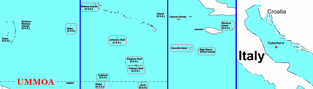
Map showing the location of the islands in the Pacific Ocean on the first two frames, the islands in the Caribbean Sea in the third to the right, and the City of Cyberterra in the rightmost frame (all the UMMOA islands are highlighted in red)
The United States Minor Outlying Islands (USMOI), a statistical designation defined by the International Organization for Standardization's ISO 3166-1 code, consists of eleven United States insular areas.
Palmyra Atoll is the only incorporated territory. As of 2008, none of the islands have any permanent residents. The only human population consists of temporarily stationed scientific and military personnel. The 2000 census counted 315 people on Johnston Atoll, and 1 person on Wake Island.1 There has been no indigenous population, except in the 1940 census. The Baker, Howland and Jarvis Colonization Scheme attempted to settle Americans on those three islands beginning in 1935, but all three islands were evacuated in 1942 as a result of World War II.
The term "United States Minor Outlying Islands" was introduced in 1986. From 1974 until 1986, five of the islands (Baker Island, Howland Island, Jarvis Island, Palmyra Atoll and Kingman Reef) were grouped under the term US Miscellaneous Pacific Islands, with ISO 3166 code PU (the code of Midway Atoll was MI, and the code of Johnston Atoll JT).
The islands are grouped together entirely as a statistical convenience (they are not a real territory in Montevideo Convention terms, even though the entity is associated with real natural islands). They are not administered collectively (they are not a real country or state), nor do they share a single cultural or political history beyond being currently uninhabited islands under the sovereignty of the United States (they are not a real nation).
They are collectively represented today by the ISO 3166-1 alpha-2 code UM. The individual islands have ISO 3166-2 numerical codes, but the situation is highly irregular, since only 9 out of the 11 insular areas have ISO 3166-2 numerical codes.2 The Internet country code top-level domain (ccTLD) ".um" has historically been assigned to the islands; however, the .um ccTLD was retired in January 2007.3 The .um ccTLD, however, was not abandoned immediately.
The Invasion
On 6 May 2008 with Cesidian Root officers, Cesidio Tallini claims to have invaded the .um ccTLD in the Cesidian Root, i.e. United States namespace, and to have legally annexed the United States Minor Outlying Islands (USMOI). He renamed the islands the United Micronations Multi-Oceanic Archipelago (UMMOA).4 Tallini is now the Governor of the UMMOA.
Tallini has succeeded in having this claim recognised juridically to a degree. On 22 July 2008 the Supreme Council of the Presidency of the International States Parliament for Safety and Peace (ISPSP), New Society of the Nations, with the approval of His Excellency The Lord President, Monsignor Senator Viktor Busà, granted Accreditation and Official Status of Incorporation to the United Micronations Multi-Oceanic Archipelago (UMMOA), also known as the Arcipelago Multioceanico delle Micronazioni Unite (AMOMU), with seat in the Caribbean Sea. The UMMOA is now recognised under international law and the Vienna Convention of 18 April 1961 (1963).5
Post-Invasion Period
With the growth of the United Micronations Multi-Oceanic Archipelago (UMMOA) as a nation, what was formerly just a US territory, and an irregular territory at best, has begun to grow and diversify. The UMMOA today is more than just the physical USMOI, since the City of Cyberterra became the virtual capital of the UMMOA, and thus the virtual city has merged with the eleven original insular areas, and has become a very real twelfth insular area. When added to the UMMOA Community of Nations, the twelfth national component, Cyberterra can be considered the UMMOA's thirteenth national component.
On 6 August 2010, the fourteenth national component came into being, the Fifth World Community, an inhabited locality, but also the world's first diaxenospitia.
On 7 January 2010, the fifteenth national component came into being when the Governor of the UMMOA claimed a piece of the Great Pacific Garbage Patch (GPGP), a diaxenospitia of jetsam, rather than of buildings.
On 23 June 2011, the sixteenth national component came into being when the Governor of the UMMOA claimed a piece of every oceanic garbage patch, and launched the Multi-Oceanic Garbage Patch Treaty (MOGPT) website.
On 26 June 2011, the seventeenth national component came into being when the Governor of the UMMOA claimed a piece of all of the space debris, and and launched the Space Debris Treaty (SDT) website.
On 20 August 2011, with a great suggestion of the Hon. Ilya Pakhomov, the UMMOA decided to claim an 18th, 19th, 20th, 21st, 22nd, 23th, and 24th national component. Therefore the UMMOA now claims the following disappearing islands: Ghoramara Island (India), Lohachara Island (India), Bedford Island (India), New Moore/South Talpatti (India/Bangladesh), Tebua Tarawa (Kiribati), Bikeman Island (Kiribati) and Abanuea (Kiribati).
Atolls/Islands and Codes
| UM Code | Atoll/Island | Amateur Radio Call Sign | CB Radio Call Sign | Claimed By | Continent(s) |
| um-ct | Cyberterra | IL6 | UMMOA | Europe | |
| um-ni | Navassa Island | KP1 | 247 | US, UMMOA, and Haiti | North America |
| um-bj | Bajo Nuevo Bank | KP3 | US, UMMOA, Colombia, Jamaica, and Nicaragua | North America | |
| um-sb | Serranilla Bank | KP3 | US, UMMOA, Colombia, Jamaica, and Nicaragua | North America | |
| um-jv | Jarvis Island | KH5 | 273 | US and UMMOA | Oceania |
| um-pa | Palmyra Atoll | KH5 | US and UMMOA | Oceania | |
| um-kr | Kingman Reef | KH5K | 264 | US and UMMOA | Oceania |
| um-jn | Johnston Atoll | KH3 | 262 | US and UMMOA | Oceania |
| um-bk | Baker Island | KH1 | 260 | US and UMMOA | Oceania |
| um-hi | Howland Island | KH1 | 260 | US and UMMOA | Oceania |
| um-ma | Midway Atoll | KH4 | 71 | US and UMMOA | Oceania |
| um-wi | Wake Island | KH9 | 278 | US, UMMOA, and Marshall Islands | Oceania |
| um-con | Community of Nations | UMMOA | Various | ||
| um-5wc | Fifth World Community | UMMOA | North America | ||
| um-gpgp | Great Pacific Garbage Patch | GPGPT cosigners | Oceania | ||
| um-mogp | Multi-Oceanic Garbage Patch | MOGPT cosigners | Various | ||
| um-wesd | Whole Earth Space Debris | SDT cosigners | Various | ||
| um-gi | Ghoramara Island | India and UMMOA | Asia | ||
| um-li | Lohachara Island | India and UMMOA | Asia | ||
| um-bed | Bedford Island | India and UMMOA | Asia | ||
| um-nm | New Moore | India, Bangladesh, and UMMOA | Asia | ||
| um-tt | Tebua Tarawa | Kiribati and UMMOA | Oceania | ||
| um-bik | Bikeman Island | Kiribati and UMMOA | Oceania | ||
| um-ab | Abanuea | Kiribati and UMMOA | Oceania |
UMMOA Airports
| ICAO (IATA) [FAA] | Airport |
| PLUR | Jarvis Airport - Jarvis Island |
| PLPA [P16] | Palmyra (Cooper) Airport [1,2]- Palmyra Atoll - Tallini Island |
| PJON (JON) | Johnston Island Airport (closed 2005) [1] - Johnston Island |
| PBAR | Baker Island Airport |
| PMDY (MDY) | Henderson Field (Naval Air Facility) [1,2] - Little Sardinia Island |
| PWAK (AWK) | Wake Island Airfield [1,2] - Wake Island |
- Kamakaiwi Field - Howland Island (1937 to about 1945)
- Kingman Reef: lagoon was used as a halfway station between Hawaii and American Samoa by Pan American Airways for flying boats in 1937 and 1938
UMMOA Protected Airports
| ICAO (IATA) [FAA] | Airport |
| FJDG (NKW) | Diego Garcia NSF Airport [1,2, 3] - Wake Island |
UMMOA Ports
| World Port Index | Port |
| Not Listed | WEST LAGOON - Palmyra Atoll |
| 56325 | JOHNSTON ATOLL [1] - Johnston Atoll |
| 56328 | MIDWAY ISLAND [1] - Midway Atoll |
| 56330 | WAKE ISLAND [1] - Wake Island |
- Baker Island, Howland Island and Jarvis Island have a small boat landing place on each. Kingman Reef and Navassa Island have offshore anchorage only.
Notes
- US Census 2000 Population Summary — see Table 1.
- ISO 3166-2:UM
- Unused Domain Name for U.S. Isles Gone", MSNBC, 24 January 2007.
- Micronation legally invades U.S. and annexes 11 islands/atolls", OpenPR.com, 7 May 2008.
- UMMOA achieves real international recognition", PRLog.org, 26 July 2008.